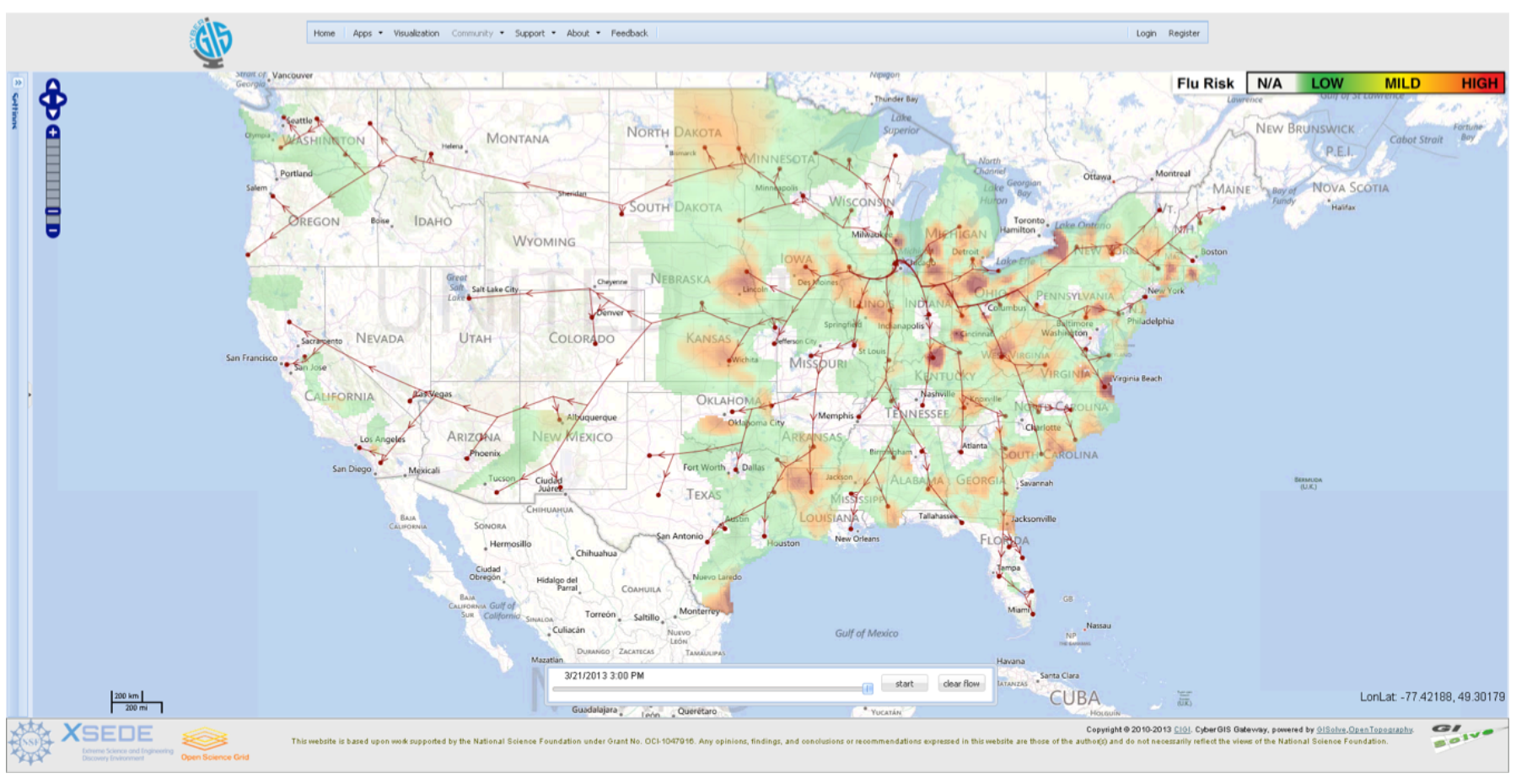
This research aims to demonstrate the use of massive social media data to interactively analyze spatiotemporal events across spatial and temporal scales, by establishing a data-driven framework using cyberGIS to resolve aforementioned challenges. Specifically, FluMapper—an application on the CyberGIS Gateway—is employed as a case study to demonstrate the data-driven framework and seamless integration of massive location-based social media data and spatial analytical services within the online problem solving environment of the Gateway.
FluMapper presents integrated results from two complementary spatial analyses: (i) an interactive exploration of spatial distribution of flu risk and (ii) dynamic mapping of movement patterns, across multiple spatial, and temporal scales. The seamless integration of these two analyses through the framework illustrates the potential of cyberGIS to resolve the compute and data challenges of analyzing near real-time social media data in an efficient and scalable manner and to support interactive visualization.
Sponsored by: National Science Foundation (NSF)
People: Anand Padmanabhan, Shaowen Wang
Publications:
- Wang, S., Cao, G., Zhang, Z., Zhao, Y., and Padmanabhan, A. 2013. “A CyberGIS Environment for Analysis of Location-Based Social Media Data.” In: Location-Based Computing and Services, 2nd Edition, ed. A. K. Hassan and H. Amin, CRC Press, pages: 187-205
- Hwang, M., Wang, S., Cao, G., Padmanabhan, A., Zhang, Z. 2013. “Spatiotemporal Transformation of Social Media Geostreams: A Case Study of Twitter for Flu Risk Analysis.” In: Proceedings of the 4th ACM SIGSPATIAL International Workshop on GeoStreaming (IWGS), November 5 2013, Orlando, Florida, USA
- Padmanabhan, A., Wang, S., Cao, G., Hwang, M., Zhao, Y., Zhang, Z., and Gao, Y. 2013. “FluMapper: An Interactive CyberGIS Environment for Massive Location-based Social Media Data Analysis.” In: Proceedings of XSEDE 2013: Extreme Science and Engineering Discovery Environment: Gateway to Discovery, Jul 22-25 2013, San Diego, CA, USA.
- Zhang, Z., Wang, S., Cao, G., Padmanabhan, A., Wu, K. 2014. “A Scalable Approach to Extracting Mobility Patterns from Social Media Data.” In: Proceedings of the 22nd International Conference on Geoinformatics (Geoinformatics 2014), pages 1-6, IEEE Xplore Digital Library. http://ieeexplore.ieee.org/abstract/document/6950845/
- Padmanabhan, A., Wang, S., Cao, G., Hwang, M., Zhang, Z., Gao, Y., Soltani, K., and Liu, Y.Y. 2014. “FluMapper: A CyberGIS Application for Interactive Analysis of Massive Location-based Social Media.” Concurrency and Computation: Practice and Experience. 26(13), 2253–2265. http://dx.doi.org/10.1002/cpe.3287
- Soltani, K., Padmanabhan, A., and Wang, S. 2015. “MovePattern:Interactive framework to provide scalable visualization of movement patterns”. Proceedings of the 2015 ACM SIGSPATIAL International Workshop on Computational Transportation Science, Nov 3-6, Seattle, WA.
- Cao, G., Wang, S., Hwang, M., Padmanabhan, A., Zhang, Z., and Soltani, K. 2015. “A Scalable Framework for Spatiotemporal Analysis of Location-based Social Media Data”. Computers, Environment and Urban Systems. 51, 70-82. https://doi.org/10.1016/j.compenvurbsys.2015.01.002
- Helwig, N.E., Gao, Y., Wang, S. and Ma, P., 2015. Analyzing spatiotemporal trends in social media data via smoothing spline analysis of variance. Spatial Statistics, 14, pp.491-504.
- Gao, Y., Wang, S., Padmanabhan, A., Yin, J. and Cao, G., 2018. Mapping spatiotemporal patterns of events using social media: a case study of influenza trends. International Journal of Geographical Information Science, 32(3), pp.425-449.