
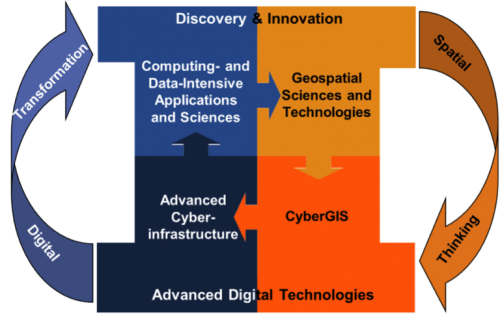
The CyberGIS Center for Advanced Digital and Spatial Studies (CyberGIS Center) was established in 2013 as a cross- and trans-disciplinary center engaging a number of units at the University of Illinois at Urbana-Champaign and diverse partners in the US and world. CyberGIS—referred to as geographic information science and systems (GIS) based on advanced computing and cyberinfrastructure —represents a vibrant interdisciplinary field for bridging advanced cyberinfrastructure, geographic information science and technologies, and various geospatial knowledge domains to solve pressing scientific and societal problems.
Spatially heterogeneous and multi-scale changes across the globe, such as population growth, climate change, and accelerated resource and environmental degradation, have posed grand challenges ranging from energy and environmental sustainability to health and wellness. To tackle these challenges, which exhibit tremendous geo and spatial complexity, requires critical knowledge of spatial patterns and their driving processes across a number of spatial and temporal scales by combining rich spatiotemporal data, analytics and models to form novel problem-solving approaches enabled by cyberGIS.
The CyberGIS Center, directed by Dr. Shaowen Wang, is located in the National History Building on the campus of the University of Illinois at Urbana-Champaign.
CyberGIS Center vision
© CyberGIS Center